Riding in Xinjiang ⑦: leave narati, walk through the intoxicating Gongnaisi River Valley, and encounter the sunset on Bayinbuluke grassland
On the fifth day of the trip, I started from Nalati Resort and walked through the [Gongnaisi River Valley] all day.

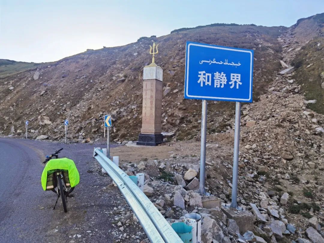
Before sunset, I crossed the third Daban [laerdun] of Duku highway, which is the junction of Ili Kazak Autonomous Prefecture and Bayingolin Mongolian Autonomous Prefecture.

The altitude is 2672 meters.

I went down the mountain and met the [Bayinbuluke grassland] at sunset.

Before dark, I reached Bayin town.

It takes about 9 hours to ride 70 kilometers.

👆 After eating breakfast in the morning of narati, I went back along the road that I came yesterday.

The valley on one side was rolling and shrouded in clouds, which attracted passers-by to stop and take photos; Riding in such an environment seems to fall into the picture of nature by mistake.

With rows of Tianshan spruces crossing the valley, herdsmen drive their cattle and sheep by frequently.

Yesterday, the pasture in nilek on the other side of the mountain was about to stop grazing, and there was such an intoxicating scenery here in September.

It all depended on the road under the wheels 👆 Scenery along the way | Gongnaisi River Valley leaves narati and continues to go straight along G217.

The roads are winding, and the scenery on both sides changes one after another; The sound of the steam whistle and the cries of cattle and sheep gradually disappeared from my ears, and instead of the gurgling River, the mountain spruce also came to my side; The sky overhead, the flowing river, the breathing air, the rare good weather, everything is so clean and clear! Walking through the valley, there was silence except for cars passing by occasionally.

In the afternoon, they took a rest by the riverside to enjoy the cool and eat; Wash your face with the cool river in your hands, and you feel refreshed! Lying under the tree with the wind and water, without thinking how far the road ahead is, let’s stop for a while…
As the altitude continues to rise, you can see the opposite road by looking up around the corner of the intersection.
When you don’t know to get to the mountain pass, you can’t help but wonder; When we climbed several consecutive turns, looked back at the intersection where we were resting, saw the car the size of an ant passing by, and thought about us, our shadow was even smaller; If you omit climbing, all the sightseeing will be possible and the profound educational significance will be lost.
By chance, I saw a figure moving on the ridge.
I quickly stopped and pulled out my mobile phone to have a look.
I found that it was a shepherd on horseback.
I clicked the shutter and the shepherd disappeared in the twinkling of an eye.
When I think of this moment, I feel that this scene seems to be waiting for me.
I want to wave to attract attention, but I am afraid to disturb him.
If I choose only one photo representing Xinjiang, I will not hesitate to choose this one \a person who is satisfied with a simple life.
The territory of life is broader 👆 Lardundaban is 2672 meters above sea level.
When the tall spruce on the ridge is below the line of sight, other tree species are mixed and show yellow or red colors, so we can feel the scene of autumn; Horses in twos and threes were grazing on the hillside.
Sheep bleated as they ate, as if to say, “brothers and sisters, the grass ahead is tender.
The sun is going down.
Hurry up!” Climbing and turning, I saw a section of snow proof corridor again.
I thought it was not far from the mountain pass.
There were two lines of small characters carved on the wall on the right.
When I walked in, I saw: it was built in laerdun Daban in October 1984, and the army zero one two three! The wall looks very white.
It should have been painted not long ago.
Black and yellow reflective stripes are pasted on both sides of the hole.
The corridor is located at the bend to remind the passing vehicles to slow down! After passing the snow prevention corridor, there is a small slope less than 100 meters.
When turning the corner, the view is wide, but no obvious Daban sign is seen, indicating that the corridor is at the highest point! Lardundaban is the watershed of the Gongnaisi River and Kaidu River.
It is an important hole in the Tianshan Road of the ancient “Silk Road”.
At this moment, the sun is setting.
After taking a simple photo, I grade the slope all the way.
On the way, I saw the road signs in the peaceful world.
The stone tablets beside me are very characteristic.
From here, I bid farewell to Ili Prefecture and began to embark on the journey of Bayingolin Mongolian Autonomous Prefecture.
👆 Bayinbuluke town has a slope of about 12 kilometers to the foot of the mountain.
The warm sunshine spreads all over the earth, and the mountains in the distance are covered with snow; Waiting for the sunset at the roadside, I delayed my journey.
Brother Li met me at the intersection ahead.
When they arrived at Bayin Town, they were already a million lights.
I walked around the street looking for a suitable hotel.
After settling down, I went out to look for food.
The restaurant opposite the hotel had a good business.
After dinner, there were many people coming in and out.
Brother Li had a good appetite and was terrified when he talked about being chased by a dog…
This part of the night road is adjacent to the Kaidu River wetland.
If it is passing by during the day, the scenery must be good, which is a little pity.
However, safety first, because he was greedy for the beautiful scenery at sunset, Would you do that? Reference: 1 Gongnaisi grassland Baidu Encyclopedia 2 Turn to Netease by laladun Daban..

